Cart
0
item(s)
item(s)
0 item(s)
No products
To be determined
Shipping
$ 0.00
Total
Product successfully added to your shopping cart
Quantity
Total
There are 0 items in your cart.
There is 1 item in your cart.
Total products
Total shipping
To be determined
Total


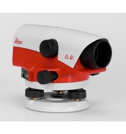
Leica NA730 Automatic Optical Surveying
NA730
Used
$ 785.00 tax incl.
tax incl.
The Leica NA730 is an advanced automatic optical level, meticulously crafted for professionals in the fields of land surveying, engineering, construction, and outdoor mapping. Renowned for its precision and reliability, this instrument sets the standard for accurate leveling and elevation measurement in diverse outdoor environments.
Description: Leica NA730 Automatic Optical Level
The Leica NA730 is an advanced automatic optical level, meticulously crafted for professionals in the fields of land surveying, engineering, construction, and outdoor mapping. Renowned for its precision and reliability, this instrument sets the standard for accurate leveling and elevation measurement in diverse outdoor environments. With cutting-edge features and robust construction, the Leica NA730 simplifies complex surveying tasks while delivering exceptional results.
Features:
Automatic Self-Leveling:
Compensator Mechanism: The Leica NA730 incorporates an advanced compensator mechanism, ensuring automatic self-leveling. This feature eliminates manual leveling errors, streamlining the surveying process.
High-Quality Optics:
Optical Clarity: Equipped with multi-coated optics, the instrument delivers impeccable image clarity, reducing distortion and glare.
Magnification: Typically featuring 30x magnification, enabling precise target observation, even at significant distances.
Remarkable Accuracy:
Accuracy: Known for its extraordinary accuracy, it typically achieves accuracy levels within 1.0mm per 1 kilometer of measurement, ensuring precise and dependable results.
Extensive Working Range:
Coverage: Boasts an extensive working range that often exceeds 100 meters, catering to a broad spectrum of outdoor surveying tasks.
Weather-Resistant Design:
Durability: Engineered with rugged and weather-resistant materials, it thrives in outdoor conditions, withstanding rain, dust, and harsh environments.
Tripod Compatibility:
Stability: Compatible with standard surveying tripods, providing stability during measurements, a fundamental requirement for accuracy.
Leveling Rod Integration:
Elevation Measurements: Seamlessly integrates with leveling rods, facilitating elevation measurements and contour mapping.
Data Recording Capability (Optional):
Digital Efficiency: Advanced models may feature data recording capabilities, allowing for the digital storage, analysis, and export of measurement data. This streamlines data management and enhances workflow efficiency.
Optional Horizontal Circle:
Angular Precision: An optional horizontal circle with a degree scale enables precise angular measurements and orientation tasks, adding to its measurement flexibility.
Fine Horizontal Adjustment:
Precision Control: Equipped with fine horizontal adjustment controls, ensuring pinpoint targeting and precise leveling for enhanced measurement control.
Specifications:
- Instrument Type: Automatic Optical Level
- Purpose: Accurate leveling, elevation measurement, and establishing level reference points in outdoor surveying applications.
- Magnification: Typically 30x magnification.
- Accuracy: Typically within 1.0mm per 1 kilometer of measurement.
- Working Range: Often exceeding 100 meters.
- Optics: Multi-coated optics for superior clarity.
- Weather Resistance: Rugged and weather-resistant construction.
- Tripod Compatibility: Compatible with standard surveying tripods.
- Leveling Rod Compatibility: Integration with leveling rods for elevation measurements.
- Data Recording (Optional): Digital data storage, analysis, and export capabilities (available on select models).
- Horizontal Circle (Optional): Optional horizontal circle with degree scale for angular measurements and orientation tasks.
- Fine Horizontal Adjustment: Fine horizontal adjustment controls for precise targeting and leveling.
No customer reviews for the moment.
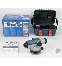
Accessories


9 products in category:
 New
Sale!
New
Sale!
 New
Sale!
New
Sale!
 New
Sale!
New
Sale!
 New
Sale!
New
Sale!
 New
Sale!
New
Sale!
 New
Sale!
New
Sale!
 New
Sale!
New
Sale!
 New
Sale!
New
Sale!
 New
Sale!
New
Sale!